indonesia corners

indonesia corners
Showing posts with label Gajah Mada. Show all posts

Wednesday, June 22, 2016

Seize China Fishing Boat in Natuna EEZ, No Compromise About It


Indonesia has long settled the boundary around Natuna EEZ in accordance with UNCLOS with its neighboring countries. The boundary is now there firmly set up and recognized internationally except China. Indonesia regards China’s unilateral claim on the part of Natuna EEZ as their fishing ground is baseless. For Indonesia, holding negotiation with any country who tries to challenge its EEZ  is useless.

China has a dual system in running their country. In dealing with government affairs, it's Communist Party who takes the charge while in business the party allows the government to adopt liberalism. The Communist Party knows that their Nine Dash-lines product will confront the ASEAN countries' interest in South China Sea (SCS) while at the same time are willing to keep the business relationship with ASEAN countries intact. 

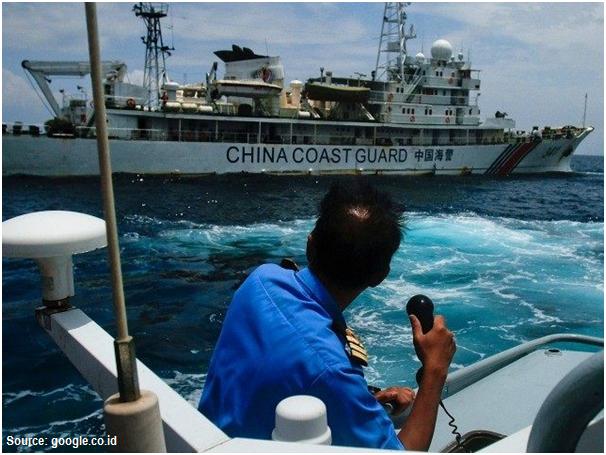
China doesn’t seem confident in what they do in Natuna water. They are always escorting their fishing boats with their coastguards, the funniest thing that a country has ever done. This is exactly what happened related to incidents taking in Natuna EEZ. The last incident occurred on June 18, 2016, when the Navy's KRI Imam Bonjol 383 chased twelve Chinese fishing vessels a firing towards one of them (Yueyandong Yu 19038) after giving several warnings in concordance with the standard procedure. The warship commander stood firm and simply ignored the Chinese coastguards that tried to interfere with the vessel seizing.


The maneuver of so many China fishing boats could be suspected to test the water rather than solely catching the fish. Having faced with such a situation, Indonesia must show their stern position to the world that Indonesia would never back off no matter the provocation comes from. For Indonesia, the integrity of its EEZ is a matter of principle and will defend it at all cost.

Indonesia should be very cautious towards the sincerity of China's statement on their recognition on the Natuna Islands as an integral part of Indonesia territory. It is now clear that China recognizes only the islands but not their surrounding water. The issue becomes more dangerous as China had issued a position paper in December 2014, that the dispute in SCS was basically a matter of sovereignty, not exploitation rights. Does China have a hidden agenda that sometime in the future they will claim the Dash-lines crossing Natuna EEZ as the delimitation of their sovereignty?


Being aware of China aggressiveness in imposing its claim, Indonesia could no longer maintain its neutral position. Indonesia should not behave like an ostrich and being selfish ignoring their fellows ASEAN desperately confronting head-to-head with China in SCS. ASEAN should stand united against China and as the biggest nation among the community, Indonesia should stand in front. 

One example of the embarrassing diplomatic move was what happened in ASEAN foreign ministers meeting in Kunming, China, June 14, 2016. It was sad to see that ASEAN was broken apart letting China take the leading role pressuring ASEAN countries to adopt Beijing’s stance in SCS. China has been keeping eyes on the gas-rich area in SCS and possibly in Natuna water as well. Their claim on the right to exploit marine resources in Natuna sea could be extended to the right to exploit continental shelf beneath. This suspicion is logic if we look to what they did to build an oil platform in Vietnam offshore in 2014 which they claimed as theirs.

China claimed that the Nine Dash-Lines was marine empire boundary established in the era of the Ming Dynasty around 12th century. Historically, it is doubted that China ever ruled the waves imposing their power even on SCS. China was never becoming a maritime country and even if they were so, it should occur in a very short period. Indonesia, on the other hand, was a maritime nation for a long time. At the era of Sriwijaya in the 8th century and Majapahit in the 14th century, the Royal Navy conquered what is now known as Indonesian archipelago, Malaysia included,  Gajah Mada, one of the great Majapahit warlords,  sent big expeditions far west to Madagascar  (the island bears his name) and some in smaller groups had sailed up north as far Taiwan and Japan. The people in Sulawesi and the eastern part of Indonesia had traditionally sailed off far to the east across the Pacific Ocean reaching as far as New Zealand in the south, Hawaii and Eastern Islands in the remote east, the vast area that was known as the world of Tagaroa, the name of their common marine god. 


The wooden boat generation, known as Phinisi, which was used by Indonesian ancestors still survive until today going around across the archipelago. Several expeditions have been done using the replica of the ancient wooden boats heading to Madagascar and just recently to Japan proving that such journeys were not pure historical tales. Indonesia has more justification than what China did in claiming its maritime empire. Indonesia could include a much wider area by drawing Nine Thousand Dash-Lines covering those historical maritime areas, SCS included. However, Indonesia was not that crazy to seriously pose such a notorious claim.


Wednesday, January 27, 2016

Trowulan Reopens Pages of ‘Historical Book’


Most of the Indonesian students know about the Majapahit Kingdom, but only a part of them know about Trowulan, and just a few have complete data and information about this historical site. The grandeur site of Trowulan is now overshadowed by development at the surrounding areas, but all ancient buildings and temples which are still preserved today can be the authentic proof of Majapahit’s beautiful capital city in the past.  

Today, Trowulan historical site is still undergoing the process to become world heritage under the official recognition of UNESCO. While the process is going on, East Java government is now trying to excavate the artifacts buried by mud and ashes, to guard the site against  being damaged by locals or outsiders.

Excavation at Trowulan site indicates that a part of ancient settlement was buried by river mud and volcanic ashes a few meters deep under the earth. Some archaeological sites could be found in Trowulan Sub-district. There we can find ancient buildings made of bricks and are now undergoing renovation. 

MacLaine Pont, one of the Indonesian history experts, through the map he made in 1924 interpreted the perpendicular network systems in Trowulan as road networks. However, in 1981 Coordinating Body for Surveys and Mapping (Bakosurtanal) interpreted them as the discoloration anomaly of aerial surveillance photos caused by the buried water-canal networks used by locals to manage water governance system in the XIV century.


Formally there is no excavation yet at the location in order to know how to design the ancient canal networks and its functions in those days. There are some reasons for the puzzles of this historical inheritance to be disclosed which covers 49 canal segments of 50 meters width perpendicularly intersected to each other. 

As supposed to be the capital city of the Majapahit Kingdom covering the period of 1293 to 1518, Trowulan kept within the site measuring by 11 x 11 square kilometers a lot of historical artifacts, in the form of temples, bathtubs of noble elites, cemetery of kings and queens, remains of house buildings and the bordering wall of the capital city. 

A good reference can be gained from 15th century Chinese historical note describing that Majapahit palace was surrounded by brick-walls up to 10 meters high with double gates. Buildings inside the palace area were supported by wooden poles of 10-13 meters high with the floor covered with mats for common people to sit down. The roof was made of ebony planks while house roofs of common people were just made of palm fibers and straws. 


This confirmed Prapanca's historical book of Negarakertagama (1365) which described that Majapahit palace was surrounded by highly thick walls made of bricks. This Chinese account, therefore, can be taken as confirmation of other related details picture of the palace. Prapanca further illustrated that the main gate leading the palace, situated at the north, was big and made of carved iron. In front of the gate, there was a long building intended for an annual meeting with high officials. Next to it was a market and a holy crossroad. At certain spots, there were some small posts where palace guards were always ready to do their duties.

When one made his entry into north gate entrance, he could find a yard surrounded by holy buildings. At the west side of the yard, there were clusters of houses for palace guards constructed on terraces. Another gate leading to the next yard was a great hall, intended for guests waiting for their turn to meet the king. The king’s residence within the palace complex located at the east side of the yard near the great hall, consisting of a few pavilions and verandas made of carved bricks. The building was supported by the carved wooden poles quite high and big. Just outside the complex, there were buildings for Shiva and Buddhist monks, family members of the kings and high officials. A little bit outside, separated by a big yard, there was another complex of royal buildings, one of which became the residence of Gajah Mada, the commander of the Armed and Navy Forces of the kingdom.

Ruins of Trowulan ancient city were discovered in the 19th century. In his report, Sir Thomas Stamford Raffles, who served as Java Governor from 1811 to 1816, pointed out: “There are ruins of temples … spreading for miles at this region.”  But since the forest was so densely packed with teak wood, additional surveys and more detailed study were impossible. Nonetheless, Raffles, who was very interested in Javanese history and culture were definitely fascinated by what he saw and dubbed Trowulan as “The Pride of Java”.


Bad news came in 2013 that a local regent has issued a decree allowing for the construction of a steel factory right at the site which normally must be preserved. After undecided matter, fortunately, Sukarwo, East Java governor, determined that any construction at the site would only damage this historical heritage, and so he banned it for good.