
indonesia corners

indonesia corners
Showing posts with label EEZ. Show all posts

Wednesday, June 22, 2016

Seize China Fishing Boat in Natuna EEZ, No Compromise About It


Indonesia has long settled the boundary around Natuna EEZ in accordance with UNCLOS with its neighboring countries. The boundary is now there firmly set up and recognized internationally except China. Indonesia regards China’s unilateral claim on the part of Natuna EEZ as their fishing ground is baseless. For Indonesia, holding negotiation with any country who tries to challenge its EEZ  is useless.

China has a dual system in running their country. In dealing with government affairs, it's Communist Party who takes the charge while in business the party allows the government to adopt liberalism. The Communist Party knows that their Nine Dash-lines product will confront the ASEAN countries' interest in South China Sea (SCS) while at the same time are willing to keep the business relationship with ASEAN countries intact. 

China doesn’t seem confident in what they do in Natuna water. They are always escorting their fishing boats with their coastguards, the funniest thing that a country has ever done. This is exactly what happened related to incidents taking in Natuna EEZ. The last incident occurred on June 18, 2016, when the Navy's KRI Imam Bonjol 383 chased twelve Chinese fishing vessels a firing towards one of them (Yueyandong Yu 19038) after giving several warnings in concordance with the standard procedure. The warship commander stood firm and simply ignored the Chinese coastguards that tried to interfere with the vessel seizing.
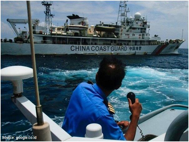


The maneuver of so many China fishing boats could be suspected to test the water rather than solely catching the fish. Having faced with such a situation, Indonesia must show their stern position to the world that Indonesia would never back off no matter the provocation comes from. For Indonesia, the integrity of its EEZ is a matter of principle and will defend it at all cost.

Indonesia should be very cautious towards the sincerity of China's statement on their recognition on the Natuna Islands as an integral part of Indonesia territory. It is now clear that China recognizes only the islands but not their surrounding water. The issue becomes more dangerous as China had issued a position paper in December 2014, that the dispute in SCS was basically a matter of sovereignty, not exploitation rights. Does China have a hidden agenda that sometime in the future they will claim the Dash-lines crossing Natuna EEZ as the delimitation of their sovereignty?


Being aware of China aggressiveness in imposing its claim, Indonesia could no longer maintain its neutral position. Indonesia should not behave like an ostrich and being selfish ignoring their fellows ASEAN desperately confronting head-to-head with China in SCS. ASEAN should stand united against China and as the biggest nation among the community, Indonesia should stand in front. 

One example of the embarrassing diplomatic move was what happened in ASEAN foreign ministers meeting in Kunming, China, June 14, 2016. It was sad to see that ASEAN was broken apart letting China take the leading role pressuring ASEAN countries to adopt Beijing’s stance in SCS. China has been keeping eyes on the gas-rich area in SCS and possibly in Natuna water as well. Their claim on the right to exploit marine resources in Natuna sea could be extended to the right to exploit continental shelf beneath. This suspicion is logic if we look to what they did to build an oil platform in Vietnam offshore in 2014 which they claimed as theirs.

China claimed that the Nine Dash-Lines was marine empire boundary established in the era of the Ming Dynasty around 12th century. Historically, it is doubted that China ever ruled the waves imposing their power even on SCS. China was never becoming a maritime country and even if they were so, it should occur in a very short period. Indonesia, on the other hand, was a maritime nation for a long time. At the era of Sriwijaya in the 8th century and Majapahit in the 14th century, the Royal Navy conquered what is now known as Indonesian archipelago, Malaysia included,  Gajah Mada, one of the great Majapahit warlords,  sent big expeditions far west to Madagascar  (the island bears his name) and some in smaller groups had sailed up north as far Taiwan and Japan. The people in Sulawesi and the eastern part of Indonesia had traditionally sailed off far to the east across the Pacific Ocean reaching as far as New Zealand in the south, Hawaii and Eastern Islands in the remote east, the vast area that was known as the world of Tagaroa, the name of their common marine god. 


The wooden boat generation, known as Phinisi, which was used by Indonesian ancestors still survive until today going around across the archipelago. Several expeditions have been done using the replica of the ancient wooden boats heading to Madagascar and just recently to Japan proving that such journeys were not pure historical tales. Indonesia has more justification than what China did in claiming its maritime empire. Indonesia could include a much wider area by drawing Nine Thousand Dash-Lines covering those historical maritime areas, SCS included. However, Indonesia was not that crazy to seriously pose such a notorious claim.


Wednesday, March 23, 2016

China Never Recognizes Indonesian EEZ in Natuna Sea


On Monday, March 21, 2016, the Indonesian Minister of Foreign Affairs, Retno Marsudi, called the Charge d'Affaires of Chinese Embassy, Sun Wei Dei, protesting him for China aggressive violation on Indonesian right over their Exclusive Economic Zone (EEZ) around Natuna islands.  She put stress, in addition, that Indonesia is not among the claimant countries over the South  China Sea (SCS) so it is inappropriate for China to launch such aggressive action.

The incident which took place on Saturday, March 19, 2016 happened when Kway Fey 10078, Chinese fishing ship, ran around and collided in purpose the Indonesian coast guard KP Hiu 11 that pursued itThree Indonesian officials jumped and took over the Chinese boat transferring the Chinese crew into KP Hiu and guarded Kway Fey towards Natuna nearest base. On the way back just about entering into Indonesian territorial sea, a Chinese coast guard ship that silently pursued them unexpectedly collided and immobilized Kway Fey. Anticipating an aggravated situation, the three Indonesian officials jumped back to KP Hiu abandoning Kway Fey which was then tugged away by Chinese coast guard ship to their nearest base in SCS. KP Hiu 11, however, kept arresting Chinese crew and brought them to Tiga Natuna island base waiting for a legal process.

The incident showed that China never recognizes Indonesian EEZ in the Natuna Sea. Chinese Charge d'Affaires clearly and openly stated that the fishing boat was operating in Chinese traditional fishing ground, not in Indonesia water. It is now clear for Indonesia that the issue is not merely on illegal fishing but far more seriously than that i.e. a maritime boundary dispute. 

T
he lesson never learned. Indonesia is always naive when facing a dispute such as in continental shelf or EEZ boundaries issue. Indonesia had a bad experience with Malaysia in Sipadan dispute because of its naivety. Now, when we have a maritime incident with China in Natuna Sea EEZ, again we cannot see what the bottom line is. Apart from several Indonesian ministerial protests put forward to the Chinese Embassy, the Indonesian Foreign Minister seemed satisfying herself by stating the China recognition over Indonesian sovereignty on the Natuna Islands and the right over their sea water. The minister failed, however, to notice that China only stated their recognition on Natuna sea water and never mentioned about Indonesian EEZ. 

If we look at the SCS map, it is obvious that China never challenges and claims Indonesia sovereignty upon the Natuna Islands. The Chinese nine-dash lines were clearly drawn crossing towards inside of our EEZ/Continental Shelf in the up north of Natuna Islands.  Indonesia gains nothing on China recognition on Indonesian sovereignty over Natuna islands as the Chinese nine-dash line already show it.  China indeed recognizes the Natuna island as Indonesian territory and its sea water but it doesn’t mean that it recognizes the whole Natuna EEZ area. There is an obvious overlap between Chinese dash lines and our EEZ in the up north (see the strip lines on the map). Behaving like an ostrich, Indonesia pretends as though Chinese nine-dash lines will never pose any threat to Indonesia. As a non-claimant country, Indonesia believes that the Chinese side will do similarly. 


Now it is time for Indonesia to explicitly refuse  recognizing China nine-dash lines that cross the Indonesian EEZ/Continental Shelf or elsewhere they are very remote from China mainland giving almost no room for their adversary countries to have their own EEZ. From the beginning Indonesia should judge this as Chinese injustice arrogance towards the international community especially its SCS neighboring countries, ignoring the basic principles of UNCLOS 1982. 


Indonesia should immediately withdraw its naïve role as a mediator, behaving like a good kid in the block dreaming that Beijing will be sincere towards Jakarta. China may be stunned or even mocked about Indonesian naivety as being itself a target but behaves as though nothing harmful will happen to Indonesia.  Sooner or later  Beijing will show its true determinism in imposing the whole nine-dash lines into effect including the section that crossing Indonesian EEZ/Continental Shelf. 

And the time now comes when Natuna incident emerged to the surface. China openly claimed that its fishing boat was operating in its traditional fishing ground. This is nothing but China open declaration that  Indonesian EEZ around the Natuna Islands simply doesn’t exist. It claims that what Indonesia considers as its EEZ  in Natuna sea covers what China considers as its traditional fishing ground in which the Chinese dash lines is the boundary.

Indonesia should be strong in maintaining the integrity of its EEZ as well as its Continental Shelf. Beneath Natuna water where Indonesian EEZ is located, there is abundantly oil and gas accumulations. For many decades Indonesia has developed most of that hydrocarbon fields but no single claim was heard from China on those resources. If China doesn’t recognize Indonesian EEZ around Natuna sea then sometime in the future when it feels strong enough with its military base in SCS it may also challenge the Indonesian Continental Shelf in the very same area.

Indonesian Foreign Affair Minister should be aware that the bottom line of the problem is not China recognition on Indonesian right over Natuna sea water but the explicit recognition of Indonesian EEZ and Continental Shelf both de facto and de jure. Observing China aggressiveness in imposing its nine-dash lines into effect, it is no doubt that the only language it speaks and understands to resolve the SCS dispute is power.

Indonesia is not alone in facing head to head against China.  If Indonesia likes to maintain its right in Natuna EEZ, there is no choice but to speak on the same language as China does. Indonesia should prioritize to strengthen its fleet in Natuna islands by increasing the number and capacity of coast guard ships as well as Navy warships. A strategic naval base should be built in the Natuna Islands not only to chase and intercept the illegal fishing boats but also to confront the danger from the north which now becomes real. 

Monday, February 13, 2012

A Total of 13,466 Islands Shape the Indonesian Archipelago

In the official report, it is always mentioned that the number of Indonesian islands is 17,508. This number becomes the sole reference of many institutions both domestically and abroad. This high number is obtained by including coral reefs as islets, whereas they appear only in the low tide but submerge under the water in high tide. 

Under the UN Law of the Sea (UNCLOS) the island is defined as terrain appears above the sea level regardless of whether it is in low or high tide. In addition, it should be capable to support life marked by one or more plants growing on it. As such the number of Indonesian islands should be rectified. 


Based on the geographical surveys done starting from 2007 to 2010 through inventorying and verification of the individual name of the islands and its coordinate determined by means of global positioning system (GPS), the total number of Indonesian islands is 13,466. 

The list of the island names from those surveys output has been submitted to the United Nations Group of Experts on Geographical Names (UNGEGN last year. However, the result of those surveys has not yet been stipulated in government regulation despite its significant implication in many aspects. 

Indonesia has reached many maritime boundary agreements with its neighboring countries but there are still some critical dispute areas which are rich in mineral resources such as Ambalat Sea in the northern part of Makasar Strait.


Another important marine survey that has not yet been carried out so many is bathymetry mapping due to expensive cost. In spite of that, Indonesia as successfully extending its continental self west of Aceh province measuring by 4,200 square kilometers and was approved by the UN in 2010. This extension is possible as the UNCLOS stipulates that as far as the depth of the sea water is less than 200 meters, a country may have a Continental Shelf up to 350 miles from its coastline, beyond the normal 200 miles. 

As an archipelagic state, Indonesia need to settle up all the maritime boundary issues both for fixing the Exclusive Economic Zone (EEZ) as well as Continental Shelf in order to protect our fishermen from being caught by neighbor authority, intercept and seize the illegal fishing boats, conserve marine biodiversity and give firm legal support in offering mineral exploration blocks.